The Full Highland Trek: Laugavegur Meets Fimmvörðuháls
Eighty kilometers, 3000 meters of elevation gain, and completely unpredictable weather — this is Iceland’s ultimate trek. The Laugavegur Fimmvörðuháls combo combines two epic trails into one legendary journey through Iceland’s highlands. You’ll cross volcanic craters, glacier valleys, black sand deserts, 26 cascading waterfalls, with the iconic Skógafoss as the ultimate finale. It’s easy to understand why the Laugavegur draws hikers from around the world once you experience how dramatically the landscape shifts from one day to the next.

This hike was our reason for going to Iceland. The kids had Iceland at the top of their bucket lists, and I had this hike at the top of my Iceland list. When I showed it to them, they were immediately in- or at least most of them were. It delivered in every way possible- from breathtaking views to soul testing storms, injuries, weariness, and a spot on our greatest hits list.

When trekking the Laugavegur, everyone has to answer the question if they should add the Fimmvörðuháls. The combination of the Laugavegur and Fimmvörðuháls Trails is demanding, unpredictable, and absolutely worth every step. It will reward you, challenge you, and sometimes exhaust you—but it will also give you some of the most dramatic scenery in all of Iceland. Below, you’ll find a complete breakdown of planning, route details, safety tips, and lessons we learned along the way so you can take on this adventure with confidence.
This guide assumes some familiarity with the Laugavegur; for a full overview of the trail itself, including terrain, daily flow, and hut locations, see the Laugavegur trail overview
Laugavegur Planning at a Glance
This planning overview is designed to help you organize the most important parts of your trip without overcomplicating things
Want everything organized in one place? Explore the Complete Laugavegur Planner.
Where to Stay the Night Before:
Important Trail Logistics:
Book Ahead:
- Rental Car/Shuttle- Discovercars
- Travel Insurance- Safety Wing
- eSIM- Saily
TL;DR
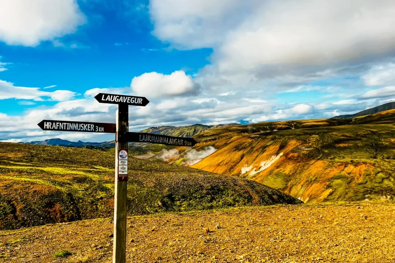
📍 Route: Landmannalaugar → Þórsmörk → Skógar
📏 Distance: ~80 km (50 mi)
⏱ Duration: 4–6 days
⬆️ Elevation Gain: ~3,000 m total
🥾 Difficulty: Challenging — long days, river crossings, high pass exposure
🌋 Terrain: Rhyolite mountains, obsidian fields, lava deserts, mossy valleys, glacier views, volcanic craters, and waterfall canyons
🚍 Transport:
• Start: Landmannalaugar, accessible by highland bus or 4×4 from Reykjavík, Hella,
Selfoss, or Hvolsvöllur
• End: Skógar busses run back to Reykjavik, Hella, Selfoss, and
Hvolsvöllur
• Note: Þórsmörk is not road-connected — you can’t exit mid-route without a deep
river crossing requiring a modified bus or super jeep.
🗓 Best Season: Mid-July to early September
🏠 Accommodation: Mountain huts (advance booking essential) or camping (no reservation needed)
💧 Water: Readily available from streams, rivers, and campgrounds
🔥 Highlights: Hot spring bathing, volcanic craters Magni & Móði, glacier views, Fimmvörðuháls ridge, and the Skógafoss finale

Quick Overview
Laugavegur & Fimmvörðuháls Combo
Distance: 80 kms (50 miles)
Point to Point: Landmannalaugar to Skogar
Elevation Gain: ~3000 m
Average Duration: 4-6 days
Difficulty Level: Challenging
—river crossings, weather exposure, and long hiking days
AllTrails Map
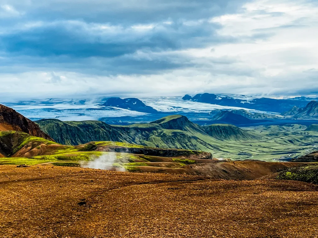
Over roughly 80 kilometers, the route links Landmannalaugar’s colorful rhyolite mountains with the green valleys of Þórsmörk and the waterfall-filled cliffs of Skógar.
The first part, the Laugavegur Trail, leads you through a wild mix of steam vents, obsidian fields, snow patches, and black ash deserts. Each valley feels like its own world, shaped by geothermal and volcanic forces that are still very much alive beneath your feet.

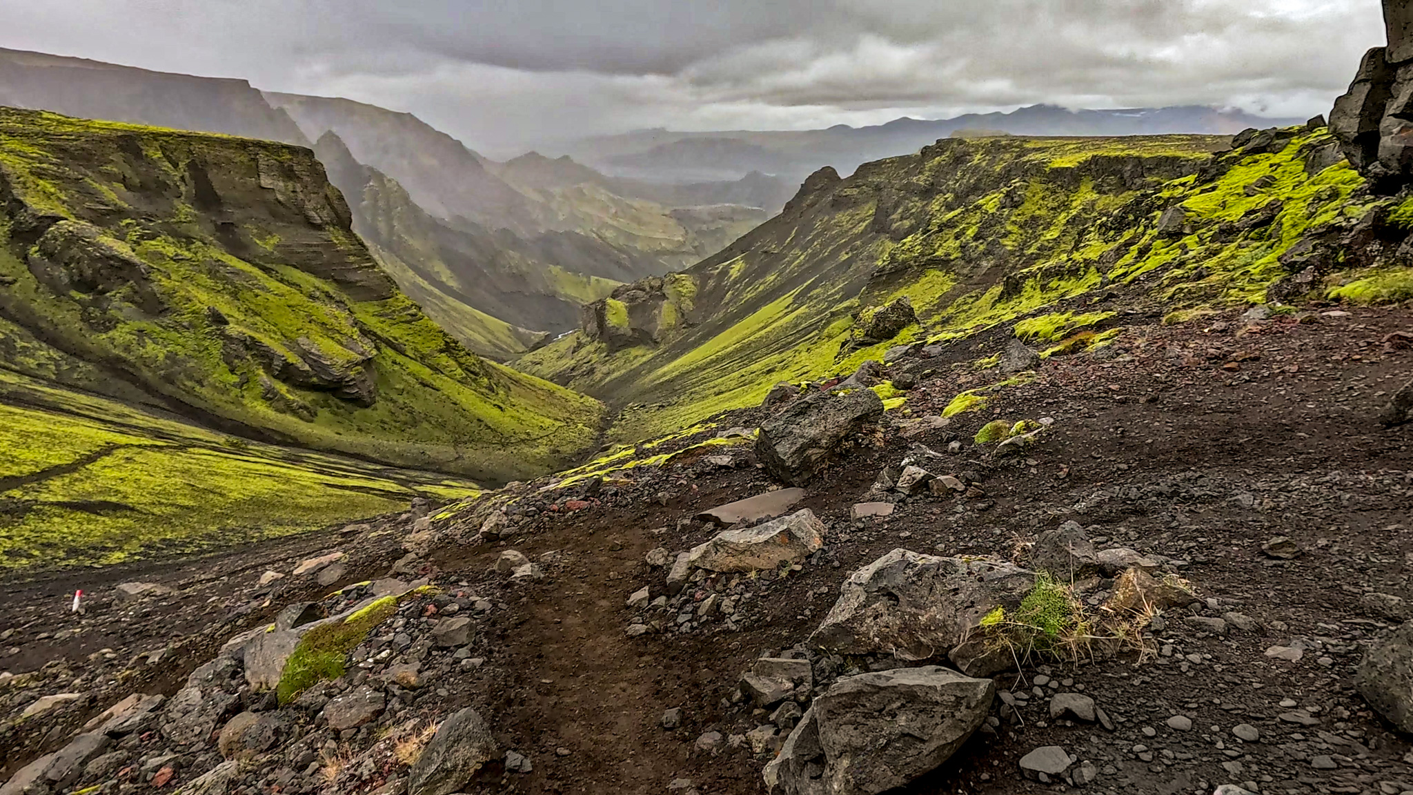
From Þórsmörk, the Fimmvörðuháls extension continues upward between two glaciers — Eyjafjallajökull and Mýrdalsjökull — before descending alongside 26 waterfalls toward the roaring Skógafoss, one of Iceland’s most famous sights.
It’s a demanding trek, but the reward is unmatched: you’ll experience every landscape Iceland is known for — volcanoes, glaciers, rhyolite mountains, mossy canyons, waterfalls, and black sand plains — in a single continuous journey.
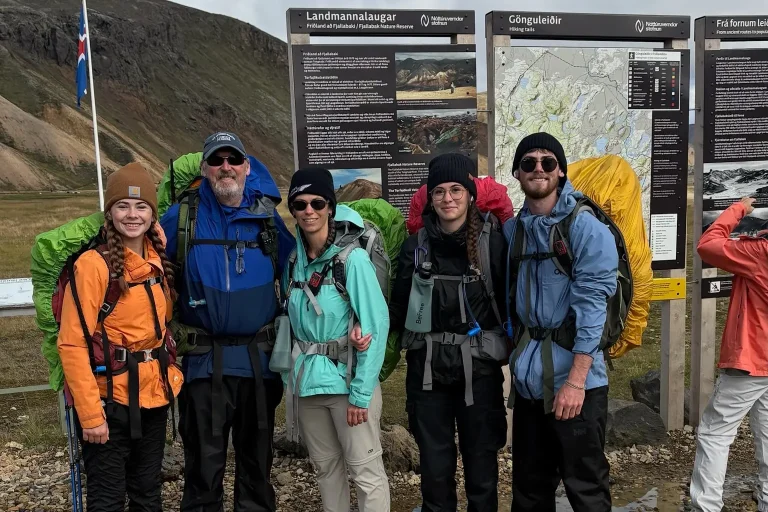
From our group of five, only two made the trek across the Fimmvörðuháls pass to Skogar. A combination of injuries and fatigue caused the rest of our group to take a bus from Þórsmörk back to Hella.
Trail Itinerary
Most people do the total trek over 5-6 days. However it is easy to make it longer or shorter. We opted for a four day itinerary, combining the first two sections of the Laugavur and the two sections of the combo trek for a challenging first and final day.
The first four days of the combined route follow the standard Laugavegur itinerary from Landmannalaugar to Þórsmörk. For the full day-by-day breakdown — including distances, elevation, huts, and pacing — see the Laugavegur day-by-day itinerary in our full trail guide.
| Day | From → To | Distance | Highlights |
| 5 | Þórsmörk → Fimmvörðuskáli (this hut closes the end of August) | ~13 km · ~1,000 m elevation gain | Steep ascent from Þórsmörk into volcanic ridge; pass the Magni and Móði craters; glacier views; first hut on the ridge |
| 5 | or Þórsmörk → Baldvinsskáli (alternate hut) | ~ 1 km past Fimmvörðuskáli | Challenging 1 km section to Baldvinsskáli with a small river crossing and rope-assisted glacier crossing |
| 6 | Baldvinsskáli → Skógar | ~ 14 km · mostly descent | long descent along Skógá River past 26 waterfalls to Skógafoss; Baldvinsskáli is the last hut on the trail |
Extending the trek over Fimmvörðuháls adds not only elevation and exposure, but also an additional day of food, accommodation, and transportation considerations — all of which influence the overall Laugavegur Trail costs.

Best Time to Hike the Laugavegur + Fimmvörðuháls Combo
The official hiking season runs from late June through mid-September, though exact conditions vary each year with snowmelt and river levels.
Because Fimmvörðuháls is more exposed and holds snow longer than Laugavegur, conditions on the combo route can vary significantly even within the same season.
- Late June:
The trail is just opening. Expect patchy snow, higher rivers from melting snow, and cold nights below freezing. Huts may be partially closed, but it’s an option for hikers seeking solitude and early-season adventure — if properly equipped. - July to mid-August:
The peak hiking season. Trails are clear, huts and campsites fully operational, and highland buses run daily. Weather is generally the most stable, though Icelandic conditions remain highly variable. - Late August–Early September:
Fewer crowds and a quieter trail make this a favourite for many hikers. However, nights are colder; severe weather is increasingly plausible, and highland bus service starts to reduce. Nevertheless, you can still enjoy mostly open trails and can even catch northern lights if skies are clear.

Our Experience Hiking the Combo Route
We originally planned to hike the Laugavegur–Fimmvörðuháls combo in the last week of August. Torrential rain and nearly impassable rivers forced us to postpone until the beginning of September.
The delay was a reminder of how quickly conditions can shift in the Icelandic highlands — and why the overall difficulty of the Laugavegur depends as much on weather and river levels as it does on distance or elevation..
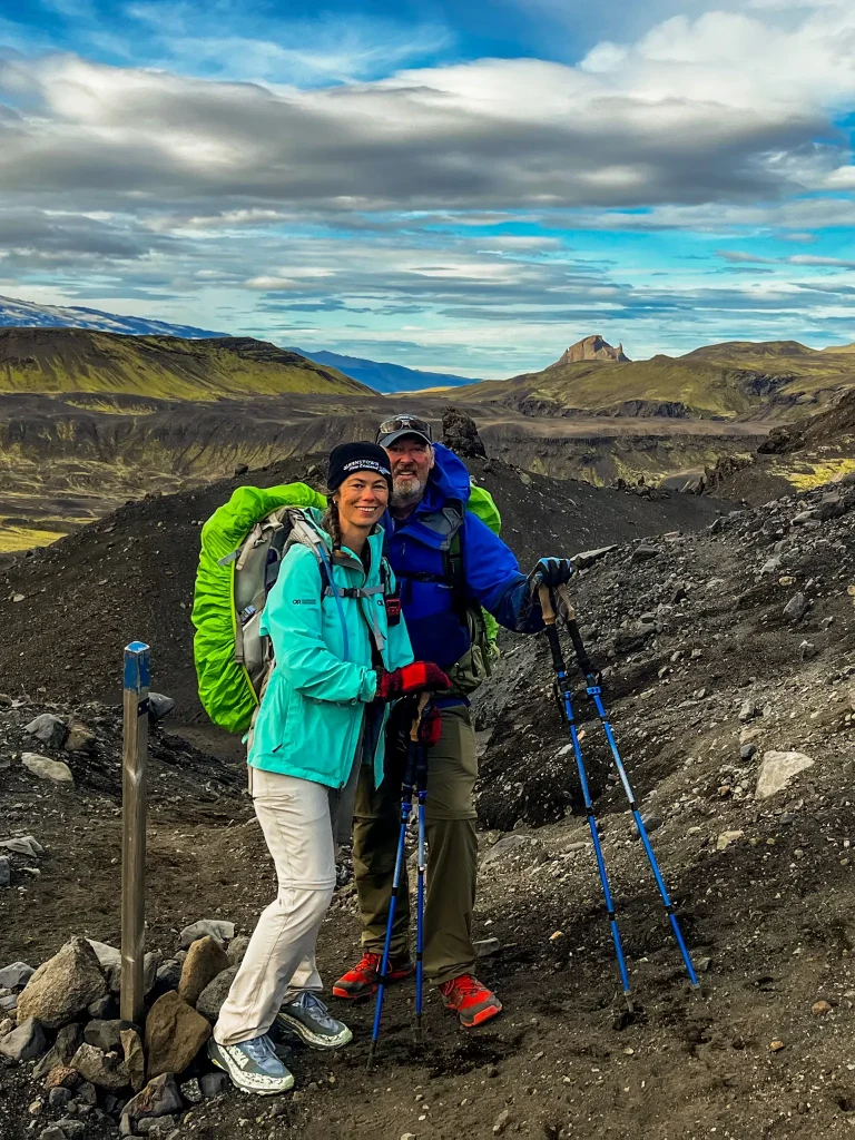
Laugavegur rewarded us with near-perfect weather. Days were mild and clear, and we even saw a brilliant northern lights display at Álftavatn. Fimmvörðuháls began just as gently. The lower sections were calm and warm enough for t-shirts, giving little indication of what was ahead.
Conditions changed at the top of the pass. Fog rolled in, rain intensified, and strong winds picked up, making this section the most physically and mentally demanding part of the hike.
Having a reliable layering system isn’t optional — it’s what allows you to stay warm, dry, and steady when the weather shifts without warning. On the descent, the weather shifted again. The rain eased, the wind settled, and the trail continued under heavy cloud rather than storm.
Before starting Fimmvörðuháls, it’s worth checking the posted forecast at the warden’s hut in Þórsmörk. That said, conditions can still be far less predictable than expected, with weather improving or deteriorating quickly between sections of the route.
Þórsmörk as a Decision Point
On the Laugavegur–Fimmvörðuháls combo, best time isn’t only about season. It’s also about conditions and capacity when you reach Þórsmörk.
Þórsmörk is where many hikers reassess whether continuing toward Fimmvörðuháls makes sense. River levels, recent weather, and time of day all matter, but so do energy levels and injuries accumulated over several days on the trail. Conditions that delay progress one afternoon may change by morning, yet personal limits don’t always reset the same way.
Our entire hiking party initially planned to complete the combo. But by the time we reached Þórsmörk, fatigue and injuries led three of our five to take a bus out rather than continue. After hearing what conditions were like on Fimmvörðuháls, each of them felt confident they had made the right choice for where they were at physically.
Knowing when to continue — and when not to — is part of choosing the best time to hike this route. Listening to your limits is just as important as watching the forecast.
Huts & Camping Overview
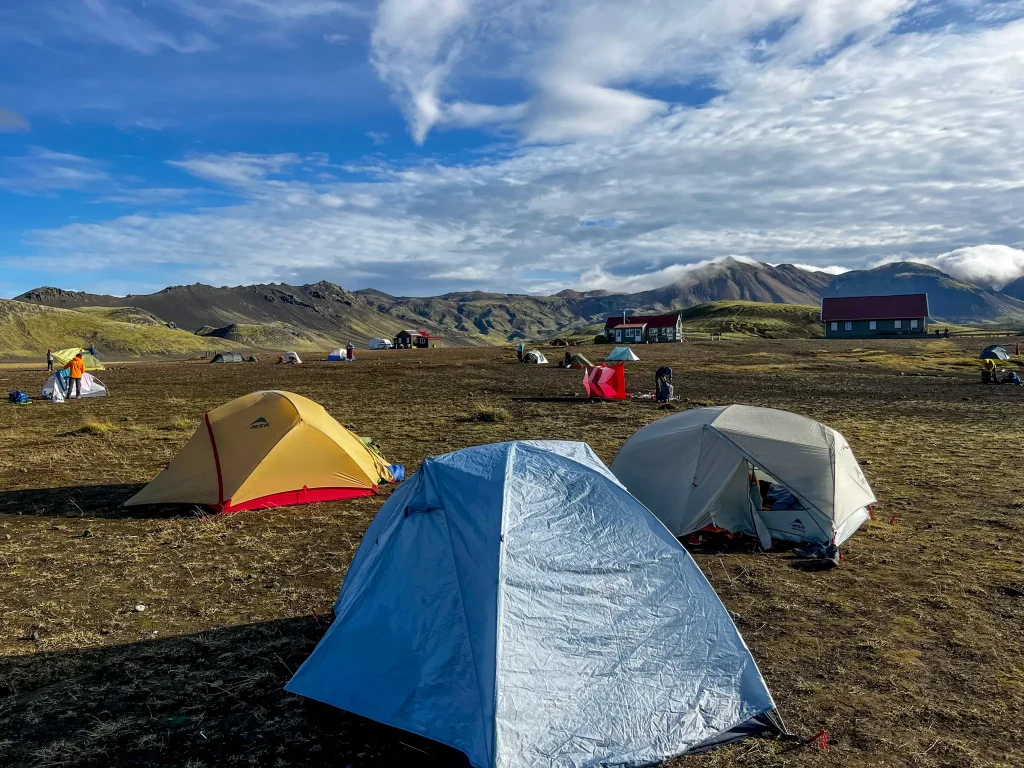
You can hike the Laugavegur–Fimmvörðuháls combo by staying in mountain huts, camping, or using a mix of both. All options follow the same route and stop at the same hut areas each night — the difference is how much structure and flexibility you want.
Reservations must be made at Fi.is for both huts and campgrounds before beginning the trek.
Mountain Huts (Overview)
Mountain huts along the route are run by the Icelandic Touring Association (FI) and offer a fixed, weather-protected option.
Cost: ~17,000 ISK per person, per night
What to bring: Sleeping bag, pillow, and all meals
Reservations: Required well in advance, especially in peak season
Camping (Overview)
Camping takes place in designated campground areas beside each hut. Wild camping is not permitted.
Cost: ~3,400 ISK per person, per night
Reservations: Must be made before beginning the hike. Check in at the warden’s office before setting up your tent.
Flexibility: Campground reservations are transferable between campgrounds once on the trail.
Camping Considerations for the Combo Route
Camping offers more flexibility, but it also requires more preparation — especially on the Fimmvörðuháls section.
Weather exposure:
Conditions can shift quickly, with strong winds and sudden storms possible at any stop, but especially on Fimmvörðuháls.
Most exposed areas:
Hrafntinnusker and Baldvinsskáli are particularly vulnerable to wind and offer little natural shelter.
Gear resilience matters:
Tents and sleep systems need to handle sustained wind, rain, and cold — especially if you’re splitting Fimmvörðuháls over two days.
In reality, everyone we personally met on Fimmvörðuháls either stayed in the hut at Baldvinsskáli or hiked the entire section in a single day.
High-wind setup basics:
- Secure all guylines and stakes
- Face the tent’s lowest profile into the wind
- Reinforce anchors with rocks or trekking poles if needed
For a deeper look at huts, campground layouts, amenities, and booking logistics at each stop, we break everything down in our camping on the Laugavegur guide.

Mixing Camping & Huts
Some hikers combine camping and huts to balance comfort, cost, and flexibility.
Pros
- Protection from the elements at the highest risk locations
- Even a couple nights of camping can create considerable cost savings
- Opportunity to rest, dry out gear etc if experiencing poor weather on the trail
Cons
- If camping any of the nights, you will still have to carry all your camping and cooking equipment for the entirety of the trail.
Transportation Logistics: Getting To and From the Trail
The Laugavegur–Fimmvörðuháls combo is a point-to-point trek across Iceland’s highlands, starting deep in the interior and finishing near the South Coast at Skógar. With no direct road connecting the start and end points, transportation takes a bit of advance planning.
This post provides the highlights, while our dedicated transportation to the Laugavegur does a deep dive into all the options.
Starting and Ending Points
Laugavegur and Fimmvörðuháls can be hiked in either direction, but it is most commonly done north to south from Landmannalaugar to Skógar
Starting Point: Landmannalaugar
- Access:
- Landmannalaugar is reached only by highland (F) roads, which are open from late June to early September and require either a 4×4 or a highland bus.
- Parking:
- There’s a small gravel parking area for those who arrive by 4×4
- Advanced reservations are required during peak season
- This parking lot is not monitored
- I recommend parking before the river crossing at Landmannalaugar in case heavy rainfall causes water levels to rise while you’re on the hike
Finishing Point: Skógar
- Access: Located right on the Ring Road (Route 1), Skógar is easy to reach by any car or public bus.
- Parking: The Skógafoss parking lot allows multi-day parking; it’s paved, spacious, and right beside the waterfall and campsite.
- Bus Stop: Buses stop directly at Skógar near the waterfall.
Shuttle Options
There is no direct transfer between Skógar and Landmannalaugar. All routes require connections through Reykjavík or other South Coast towns, which means planning transfers in advance
Round Trip Shuttle
Trex offers a Hiker’s Bus Pass that bundles transport from Reykjavik to your start point and a return back from your endpoint.
Self Drive + One-Way Shuttle
If you have a vehicle and are incorporating the trek into a longer road trip, you can consider combining driving with a shuttle.
- Parking at one of the trailheads
- Using a shuttle before or after the hike
- This option will require an overnight transfer in Hella
Our Option
We had a group of five and wanted to keep costs low. We were also comfortable splitting up to make the logistics work.
- We drove to Landmannalaugar and parked our car there.
- This allowed us to save money on shuttle fees as only one person took the bus back to Landmannalaugar to retrieve the car for everyone else.
Additional Notes
- Bus Season: Late June to early/mid-September.
- Companies to Check: Reykjavik Excursions or Trex.
- Travel Times: Reykjavík → Landmannalaugar (4–5 hrs), Skógar → Reykjavík (2.5–3 hrs).
- Make bus reservations in advance — seats often sell out in peak season, and drivers will skip stops entirely if no hikers are pre-booked for pickup.
- Confirm bus schedules to ensure your plan will work — some routes shut down early near the end of the season.
River Crossings on the Laugavegur + Fimmvörðuháls Combo
The classic Laugavegur river crossings stay the same whether or not you continue onto Fimmvörðuháls. What sets the combo route apart is the additional terrain and water obstacles you encounter once leaving Þórsmörk.
Krossá and the Transition to Fimmvörðuháls
Krossá only becomes relevant if you continue beyond Þórsmörk. For Laugavegur-only hikers, it marks the trail’s end and usually doesn’t require crossing. For combo hikers, it’s the first obstacle on the way toward Fimmvörðuháls, and whether the footbridge is in place can have a big impact on timing and logistics.
If the footbridge is out, Krossá can be dangerous. When we arrived at camp, we watched several hikers attempt to cross unsuccessfully, and one was nearly swept away in waist-deep water. By the next morning, the river had receded, and we were able to cross safely in calf-deep water. Timing is critical.
An alternative is to take a transfer from Langidalur across to Basar for about 2000 ISK per person. From there, the 2 km walk to the trailhead is an easy stroll along a gravel road.

Skógá River Crossing
If you stay on the correct trail (unlike us!), you’ll only face one river crossing on this section—right after the rope-assisted glacier crossing and just before the Baldvinsskáli hut. The crossing itself is simple and usually just requires a quick hop across.
However, the riverbanks are steep, loose, and slippery. Expect to walk back several hundred metres to find a safe spot to descend. I ended up sliding partway down the bank before crossing, so take your time and choose your line carefully.

💡 Tips for safe crossings:
- Unbuckle your pack waist and chest straps before entering the water — if you fall, you’ll want to shed the pack quickly.
- Cross as a group if needed, linking arms for stability.
- Change into dry socks afterward to prevent blisters and chill.
- Never cross where the water is opaque, white, or visibly churning. Move upstream or downstream to find a safer spot.
- When in doubt — especially near Þórsmörk — ask the rangers. Krossá changes daily and is no place to take risks.
Packing & Gear for the Combo Route
The gear required for the Laugavegur also applies to the combined Laugavegur–Fimmvörðuháls route. Sturdy boots, waterproof layers, trekking poles, and a reliable backpack remain essential regardless of where the trail ends. What changes on Fimmvörðuháls is not the gear list itself, but how heavily certain items are relied on due to increased exposure, longer days, and more sustained effort.
Combo-Specific Tips
These aren’t additions to the packing list, but areas that tend to matter more once continuing beyond Þórsmörk:
- Dry layers for the start of Fimmvörðuháls:
If water levels are high at Krossá or the footbridge is unavailable, having a dry base layer ready can make a meaningful difference before heading onto the exposed pass. - Extra energy and snacks:
The climb toward Skógar is long and sustained, especially after several days on the trail. Carb-dense, high-calorie snacks that help maintain energy late in the trek are important. - Navigation tools:
GPS, offline maps, or a physical map are important. Multiple intersecting trails near the pass, combined with poor visibility, can make route-finding more demanding than on earlier sections. - Glacier awareness:
The standard rope-assisted crossing is part of Fimmvörðuháls. While it’s well established, weather and snow conditions can increase the seriousness of this section and warrant extra caution.
For a full breakdown of clothing, sleeping, food, gear, and trail-tested tips — check out our complete Laugavegur packing list suitable for both Laugavegur and the Fimmvörðuháls extension.
Safety & Trail Conditions
Hiking the Laugavegur + Fimmvörðuháls combo is an unforgettable adventure, but it also comes with significant risks — particularly on the Fimmvörðuháls extension, where elevation and exposure increase dramatically.
Key Hazards
- Elevation & Exposure: Fimmvörðuháls climbs steadily from Þórsmörk toward the mountain pass, reaching over 1,100 m at the highest points. The ridge is exposed to wind, rain, fog, and sudden temperature drops. Even a short storm can make footing slippery and reduce visibility.
- River Crossings: Rivers are usually safe and easy to cross, but recent snowmelt or heavy rainfall can cause conditions to become dangerous. Pay close attention to depth, current, and presence of footbridges. Morning crossings are usually safer due to lower water levels.
- Low Visibility: The Fimmvörðuháls ridge is easy to lose in fog or poor visibility. On Laugavegur, Hrafntinnusker and Álftavatn also experience low visibility from fog, so stay alert and watch trail markers.
- Laugavegur: follow the blue markers.
- Fimmvörðuháls: follow the all yellow markers. Avoid yellow markers with red tops—they lead off the main trail and can require multiple river and glacier crossings to reconnect. Don’t make the same mistake we did!
Safety Tools
- SafeTravel App (ICE-SAR):
- Register your planned route and expected times.
- Receive push alerts about sudden weather changes, river hazards, or trail closures.
- Check in at key points or use the SOS function if needed.
- Offline mode works without mobile reception.
- GPS & Offline Maps:
- Carry a GPS device or smartphone with offline maps to navigate through fog, snow, or poorly marked sections.
- Fully charged device plus a portable charger is recommended.
- Weather Monitoring:
- Check safetravel.is and vedur.is daily. Highland weather can shift rapidly — sun, fog, rain, and snow may all appear within hours.
- Avoid Fimmvörðuháls during storms, heavy rain, or high winds.
- Be ready to delay, shorten, or adjust your day for safety.
General Tips
- Carry proper layers, rain gear, and waterproofed packs for gear protection.
- Keep an eye on trail markers; ridge trails can be partially obscured by snow or lava.
- Always communicate your route plan with a contact at your start point or via the Icelandic mountain huts system.
Highlights Along the Route
Laugavegur Highlights
The Laugavegur Trail is Iceland’s most famous multi-day trek, and for good reason. In just a few days, you’ll move through landscapes that feel otherworldly. Key highlights include:
- Geothermal Valleys: Steam vents, hot springs, and colorful mineral deposits near Landmannalaugar.
- Rhyolite Mountains: Vibrant hues of pink, green, orange, and gold stretch across jagged peaks.
- Obsidian Lava Fields: Black glass-like lava from ancient eruptions, contrasting sharply with the surrounding terrain.
- Snowfields & Glacial Rivers: Patches of snow and meltwater streams can make for dramatic scenery.
- Lakes & Birch Forests: Tranquil stops like Álftavatn and the birch-lined valleys near Þórsmörk offer peaceful breaks and excellent photo opportunities.


Fimmvörðuháls Highlights
The Fimmvörðuháls extension packs Icelandic geology and history into a single day of high-elevation hiking:
- Magni & Móði Craters: Newly formed craters from the 2010 Eyjafjallajökull eruption, with striking volcanic terrain.
- Eyjafjallajökull Eruption Site: Evidence of the famous 2010 eruption, including fresh lava and ash fields.
- 26 Waterfalls: Numerous cascading waterfalls along the route make this extension spectacular, culminating at the iconic Skógafoss.
- Ridge Views: Panoramic views of both glaciers and highland valleys, with exposure that rewards careful hikers with unforgettable vistas.

These highlights are only a glimpse of the diversity you’ll experience. Both trails feature constantly changing landscapes that make every day feel like a new adventure.
Laugavegur and Fimmvörðuháls Combo Final Thoughts
This hike simultaneously earned a spot on both our best and worst hikes list. The landscape is unlike anything we’ve ever seen: colorful rhyolite mountains, black sand deserts, waterfall-carved canyons, fresh volcanic craters, and glacier-filled valleys. If any trail captures the raw spirit of the Icelandic highlands, it’s this one.
It will leave you speechless in one moment and scrambling for balance in the next. On a clear day, the views are unmatched. But this is Iceland — and the price of admission often comes as howling winds, pounding rain, and thick fog that test your mental and physical limits. Sometimes all in the same hour.
It is, without question, an adventure of a lifetime. But like all great adventures, it demands careful planning and the right gear. With proper preparation, this trek rewards you with some of the most unforgettable, humbling, and awe-inspiring experiences you’ll ever collect. One way or another, it will etch its place on your greatest-adventures list.